
Figure 1: Soil Boring Log from the installation of a well-piezometer pair adjacent to the site of this study.
M. Andrea Grunauer and Michael W. Smith
Department of Geology, Mailstop 2001
Keene State College, Keene, NH 03435-2001
May 1997
Infiltration of moisture into the soil profile becomes inhibited under winter conditions. This study looked at the different factors that affect water movement in a fine sandy loam soil. Water table levels, precipitation, moisture content, soil and air temperature were monitored to provide a better understanding of the dynamics of the soil at our site.
The complexity of the hydrologic cycle is increased during winter conditions when the temperature of the soil reaches the freezing point. Many see winter as a static period regarding the movement of water from precipitation through the soil profile and into ground water recharge. Factors that affect infiltration are hydraulic conductivity, saturation, soil makeup, and porosity. However, under frozen conditions, temperature becomes the primary factor in determining a soil's permeability.
Studies have shown that infiltration in frozen ground is suppressed. The formation of ice lenses, snow cover, depth of frost penetration, all interfere with what occur under normal conditions (Woo & Marsh, 1990). This interference though, does not eliminate infiltration; precipitation still make its way through the soil profile into ground water even under winter conditions. Benson et. al. (1995) found that freezing and thawing processes, can in fact increase the hydraulic conductivity of a soil up to three hundred times.
While most of these studies have been performed under laboratory settings, we were interested in understanding how winter conditions affect infiltration in a natural environment. We believe that some component of winter precipitation does migrate from the surface down through the soil profile, eventually reaching the water table. However, other factors associated with the location of our site complicate interpretation of our results.
We selected a riparian wetland site for weekly monitoring of hydrologic conditions over the course of a winter, in an effort to better understand the dynamics of this system. While understanding these dynamics, we want to investigate which are the components that most affect infiltration.
The instrumentation used consisted of a nested water table monitoring well and shallow piezometer, nested soil thermometers (3ft, 1ft), and precipitation gauge. The well and piezometer were installed on October 8, 1996. A hand bucket auger was used to bore to a depth of 12 ft. The well and piezometer were inserted side by side. Each has an inside diameter of 1 inch, and 2 inches respectively, and is constructed of schedule 40 PVC pipe. We cataloged a boring record of the soil through which the well and piezometer run (fig. 1). Thermometers and precipitation gauge (bucket, 45 cm in height, 30 cm in diameter) were installed on November 27, 1996; previous to our first week of data collection (December 4, 1996).

Figure 1: Soil Boring Log from the installation of a well-piezometer pair adjacent to the site of this study.
The site we chose for our project is located in a woodland area located on the floodplain of the Ashuelot river, part of the Keene State College's athletic complex off of Krif Road (fig. 2). This area frequently floods during periods of intense rain and spring runoff. We chose this location due to its proximity to a wetland, and the fact that the well and piezometer had been installed previously. The actual site is located on a slight plateau to avoid surface flooding.

Figure 2: Photograph of the College Fields Site.
Field work for this project began in December, 1996 and concluded in April 1997. Samples and readings were taken weekly over this time period, except for the weeks of December 27, 1996, and April 23, 1997, when the area around the site was flooded and the site was inaccessible.
Soil samples (table 1) were taken weekly using a sliding-hammer soil-corer (5 by 15 cm cylinder, vol=294.52 cm3). Every other week a second core was taken directly below the first sample to see if there was a moisture difference along the top 30 cm of the soil horizon. The samples were transported back to the laboratory in sealed plastic bags.
We monitored water table levels using a Solinst water level meter to measure the depth to water in both the piezometer and well. Soil temperatures at the site were monitored weekly at the depths of 30 cm and 95 centimeters. All precipitation in the form of snow and rain was collected and brought to the laboratory. Every week we exchanged a bucket with precipitation with an empty bucket. Additional weather information such as external air temperature, precipitation, and river stage data were obtained from the US Army Corps of Engineers at Otter Brook Dam.
Soil samples were brought to the laboratory in plastic bags, weighed and recorded. After, the samples were placed in a drying oven at 40.5°C, and dried overnight. The next morning, the samples were weighed again; the difference in weight is the gravimetric water content. Samples were cataloged and used later to determine soil composition, porosity and saturation. Precipitation collected in the bucket was brought to the laboratory, and the liquid volume was measured, in a graduated cylinder, once it melted.
Soil composition was determined by suspending the dry soil in a contained volume of water, mixing thoroughly, and using the layering that develops as the different grain sizes settle out according to Stoke's law. Sand component settled out at 20 seconds, silt at 3 minutes, and clay composed the rest of the soil sample. With this information we then mapped our soil in a USDA soil classification triangle (fig. 3).

Figure 3: Soil Classificatoin diagram for samples from the site.
Porosity was determined by adding the dry sample to a known water volume, allowing it to mix thoroughly and recording the displacement of the water, which yields the volume of dry solids (P = Vtotal - Vsolids). Saturation was determined by using the volume of pore space and the volume of water in the sample (S= Vwater /porosity).
These volumes were then divided by the area of the collector, giving centimeter of height, to be consistent with normal measuring techniques.
We had correlation between our saturation values (fig. 4) and our well and piezometer readings (fig.5) on dates1/12/97-2/12/97, and 2/26/97-3/13/97. As saturation increased, well and piezometer levels decreased . Conversely, saturation decreased as well and piezometer levels increased (2/19/97-2/26/97; fig. 4 & fig. 5). Saturation also correlates with our precipitation readings. When saturation is low, precipitation readings were low, and viceversa (fig. 6).
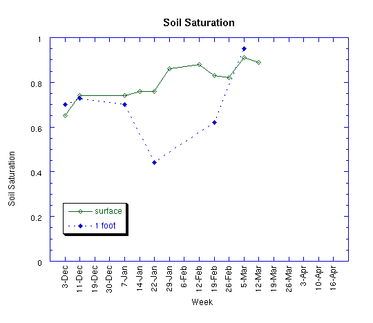
Figure 4: Soil Saturation (moisture content / porosity) over time, determined from soil core
samples taken at the surface and from approximately 1 foot below the surface.
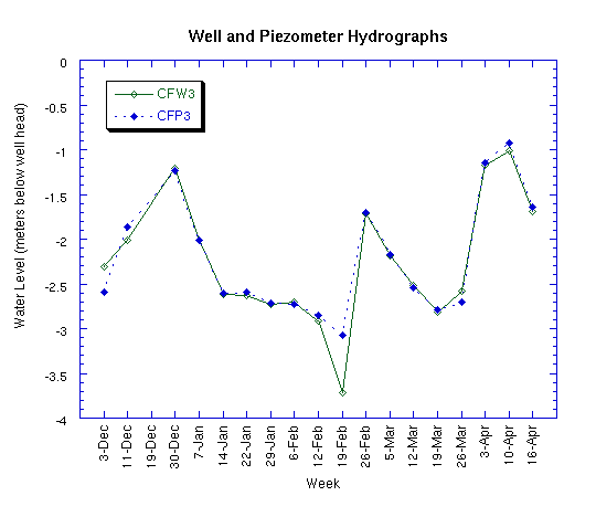
Figure 5: Water levels in well and piezometer over time. Calculated vertical hydraulic
gradient is shown in Figure 8.
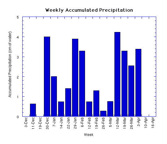
Figure 6: Weekly accumulated precipitation (in centimeters of water).
Well and piezometer readings increased dramatically after large precipitation events (fig. 6). The precipitation preceding the first rise in water levels was primarily in the form of snow. The rise in the well and piezometer readings was not immediate, but mitigated by a rise in temperature to change water from a solid to a liquid phase. Before the second rise the precipitation was rain, with some mix of snow. This was reflected more rapidly, recharging ground water in a shorter period of time than the first rise in water level.
During the period of our study, soil temperature decreased. As the soil temperature dropped, saturation in the surface soil increased. This is consistent with the idea that moisture migrates toward the freezing front. As soil temperature decreases, saturation increases as a result of both the migration of moisture, and infiltration. However, temperature drop didn't correlate with our subsurface soil saturation readings (fig. 7). This could be consistent with the theory that moisture migrates from a warmer soil to a colder soil, leaving the warmer soil dessicated(Mackay,1983).
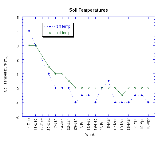
Figure 7: Soil Temperature (at depths of 1 and 3 feet below the surface) over time. Calculated
vertical temperature gradient is shown in Figure 9.
Our hydraulic head remained relatively consistent over the period of study. However, we had a large increase in the upward flow of ground water (discharge), after February 21 (fig. 8). At the beginning of April, downward flow increased, adding to the recharge of ground water. The temperature gradient consistently favored heat flow down through the soil profile except around March 20 (fig. 9).
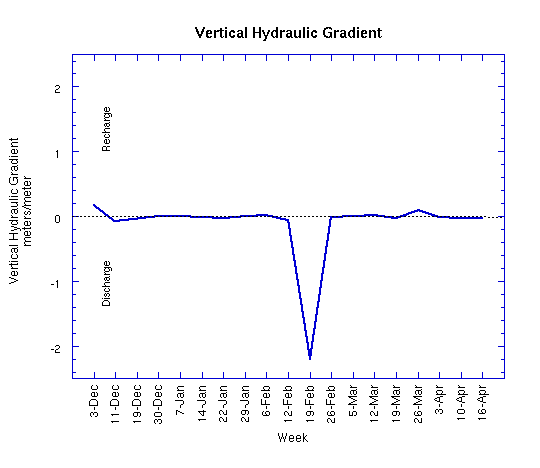
Figure 8: Vertical Hydraulic Gradient over time, showing periods of Recharge or Discharge.
Calculated from Well and Piezometer Hydrographs shown in Figure 5.
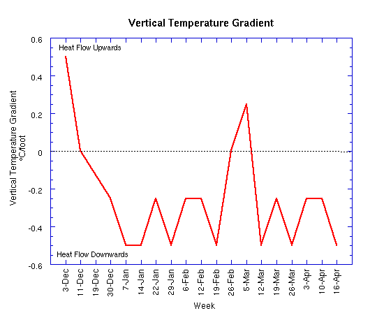
Figure 9: Vertical Temperature Gradient in the Soil over time, showing heat flow upwards
(towards surface) or downwards (surface soil warmer than deeper soil). Calculated from
Temperature records given in Figure 7.
Multiple studies about the properties of frozen soils began in the early 1900's (Yen & Nakano,1993). Understanding characteristics of frozen soil have been particularly important in the areas of engineering and hydrology. We based our conclusions, and discussion on the information obtained from a variety of articles that related to our study. Water migration, temperature gradient, and soil composition are specific factors that influence soil behavior at our site.
Water is one of the important components of soil; it can coexist in several phases: liquid, vapor and solid (Nakano, et.al., 1983). Water migration in frozen soils not only changes the structure of the soil, but also changes its physical and mechanical properties (Xiaozu et al, 1987; Yen & Nakano, 1993). Soil moisture at freezing conditions become solid decreasing a soil's permeability and porosity. Under these conditions moisture migrates to the freezing front, due to changes in pore pressure as well as relative elevation (Kane & Stein, 1983; Williams & Smith,1989; Woo & Marsh,1990). The freezing front is defined as the layer of soil where freezing of soil water occurs. As moisture moves to the freezing front, formation of ice lenses occurs (Biermans et al,1978; Kane & Chacho,1990); this is augmented by the freezing of incoming water (Yen & Nakano,1993). As temperature drops below 0°C, the water content in the surface soil freezes creating barriers to infiltration(ice lenses). In our study we observed that once the surface temperature reached 0°C, when rain occurred, ice layers formed on the surface of the soil. From February to the beginning of April, the depth of frost was at least the depth of the first core; this depth sometimes lowered to the second core (mid-February to mid-March). Mackay in 1982 determined that size of the barriers depends on the downward or both the upward and downward flow of moisture.
The temperature gradient is an important driving force for the transport of water in unsaturated frozen soils (Yen & Nakano,1993). Moisture migration and heat transfer occur in the soil with the direction of flow from warm soil to cold soil(Kane & Chacho,1990). This appears to correlate with the discharge occurrences, and water table levels in our study. Moisture migration would appear as upward flow of ground water, and decrease in water table levels. Infiltration of water in frozen ground raises the ground temperature toward O �C by the transport of sensible and latent heat (Mackay,1983; Kane & Chacho,1990). It appears that migration of moisture towards the freezing front will react similarly, by drawing out latent heat from lower depths (fig. 9).
A soil with high porosity has the ability to hold and transport a higher quantity of water, enhancing hydraulic conductivity. Fine grained soils with large surface areas have higher quantities of unfrozen water (Kane & Stein,1983). Porosity at the soil of our site was determined to be 66%. This is also reflected in our high saturation values. In an unsaturated frozen soil, its condition becomes more complex as a result of the presence of two solids: soil and ice, and two fluids: water and air (Kane & Stein,1983). Larger components of water in the soil under freezing conditions reduce the physical movement of water in the soil, by creating barriers (ice lenses). Even though these barriers inhibit infiltration, frost action (thawing and refreezing) increases permeability in a frozen soil through cracking(Benson et al, 1995).
The hydrology of soils is extremely complex and dynamic. Under winter conditions we were able to determine that infiltration does occur but is severely inhibited. Wetland areas, being more highly saturated are more dynamic than other land regions. In our site, during the winter months periods of near flooding occurred when the Ashuelot river overflowed its banks. Water flowed from the wetland to the oxbow lake, and then into the river, flooding out our entire site area once.
Our well and piezometer readings as well as the hydraulic head correlate with the flooding events. We found that high discharges at Surry Dam occurred concurrently with the flooding at our site. It's likely that water table levels were influenced by river stage. The bottom of our well is situated within a layer of gravel which may link directly with the river. This layer would remain unfrozen throughout the winter so increased water volume might increase well and piezometer levels. On March 5th we saw a 1.5 degree increase in our 95 cm thermometer reading over a two week period. This sharp rise in temperature is due to a rise in water table, such that the thermometer was saturated by warmer ground water. This could be possible evidence of connection with the river system. We feel that the river, and the change in stage have more influence in water table levels, than infiltration through the soil profile.
When designing the experiment many variables were not taken into consideration: ground water flow, river stage, accessibility to the site, and soil tension. While our results correlate with the information researched, and determined, understanding ground water flow of our site would have aided in the interpretation of our data. The movement of water into or through frozen soil is difficult to quantify because of the numerous components that can be presented in varying amounts (Kane & Stein, 1983). We feel our results reflect the complexity of our site, and while this project can be useful, it should be considered that the dynamics of this system will vary seasonally and yearly.
Further studies should consider the location of the study more carefully. In our case the river appears to be the primary factor in water table levels; to more accurately observe infiltration through the soil profile, a different site should be considered. If studies were to be continued at this site, it would be important to understand ground water flow patterns. Another variable to take into account would be soil tension. Understanding changes in pore pressure would help determine the direction of moisture movement.
Another important aspect would be to understand the parameters we looked at, over a greater range of depth. Most importantly might be to measure the depth of frost penetration to look at the size of the barrier (ice lens) to infiltration. Temperature readings only went to a depth of 95 centimeters, not deep enough to look fully at heat transfer between depth and the surface. Also looking at moisture over a greater depth would aid in interpreting moisture migration in the soil.
We would like to thank the Army Corp of Engineers at Otterbrook Dam for weather and river survey information. We would also like to thank everyone at the Cold Regions Research and Experimental Laboratory in Hanover NH for their help with our research. And thank you Dr. Allen, without your knowledge and experience we would have not been able to complete this project (we'll miss you!). Thanks also to Marc and Gretchen for their continuous support.
Benson, C.H.; Abichou, M.A.; Bosscher, P.J. (1995) Winter effects on hydraulic conductivity of compacted clay. Journal of geotechnical engineering. 121(1):69-79.
Biermans, M.B.G.M.; Dijkema, K.M.; De Vries, D.S. (1978) Water movement in porous media towards an ice front. Journal of Hydrology.37:137- 148.
Kane, D.L.; Chacho, Jr. E.F. (1990) Frozen ground effects on infiltration and runoff. Technical Council on Cold Regions Engineering Monograph. 259-300.
Kane, D.L.; Stein, J. (1983) Water movement into seasonally frozen soils. Water resources research. 19(6):1547-1557.
Mackay, R.J. (1983) Downward water movement into frozen ground, western artic coast, Canada. Canadian Journal of Earth Sciences. 20(1):120- 130.
Nakano, Y.; Tice, A.R.; Oliphant, J.L.; Jenkins, T.F. (1983) Transport of water in frozen soil I. Experimental determination oof soil-water diffusivity under isothermal conditions. U.S. Army Cold Regions Research and Engineering Laboratory, CRREL Report 83-22.
Williams, P.J.; Smith, M.W. (1989) The frozen Earth: fundamentals of geocryology. Cambridge University Press. 280-302.
Woo, M., Marsh, P. (1990) Response of soil moisture change to hydrological processes in a vontinuous permafrost environment. Nordic Hydrology. 21:235-252.
Xiaozu, X.; Oliphant, J.L.; Tice, A.R. (1987) Factors affecting water migration in frozen soils. U.S. Army Cold Regions Research and Engineering Laboratory, CRREL Report 87-9.
Yen, Y.; Nakano, Y. (1993) Estimation and measurements of transport properties of frozen soils. U.S. Army Cold Regions Research and Engineering Laboratory, CRREL 750-754.